What is the most important in the 21st century? data!
As the most authoritative application integrator of the drone industry in Shanxi, Haotian Vision has been learning the application of drones in various industries. We use the new knowledge we have learned about the UAV industry to give back to more UAV industry practitioners and some industries that can bring innovation to UAVs. Recently, we have come into contact with the category of UAV remote sensing mapping, and found that using UAV to obtain data by remote sensing is a magical thing.
Remote sensing technology is a technique for detecting and recognizing a target by sensing electromagnetic waves, visible light, and infrared rays reflected from a target or radiating from a long distance. Traditional remote sensing technologies, such as satellites, airplanes or other aircraft, are costly and have long operating cycles. It has been plagued by the popularity of remote sensing technology to obtain data. Until the emergence of drones, the small size, light weight, flexibility and maneuverability make UAV remote sensing the main force of today's remote sensing technology.
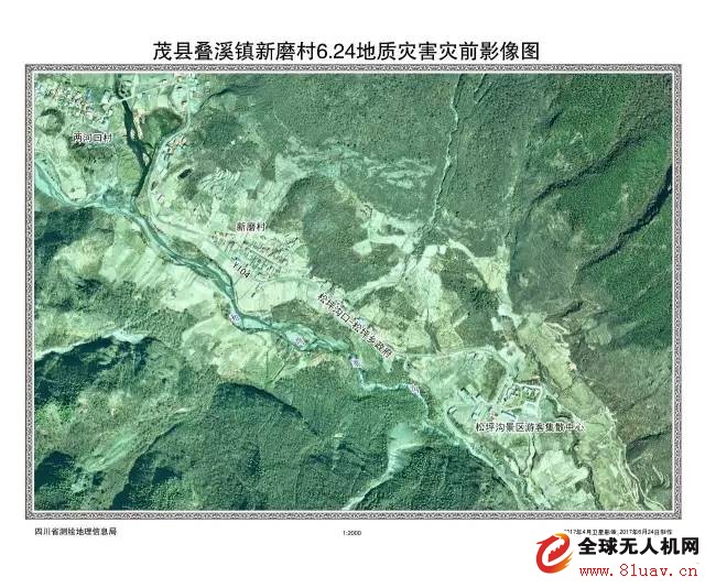
As mentioned above, both visible light and infrared light are detection methods. Let's talk about visible light mapping, using a drone camera with a visible light camera, which is a general digital and SLR camera to obtain surveying and mapping data. This kind of mapping is usually well known as some orthophoto images, and is mostly used in fields such as land surveys, navigation map updates, soil erosion monitoring, and forestry surveys. The data that can be obtained has some spatial information, contour lines, and so on.

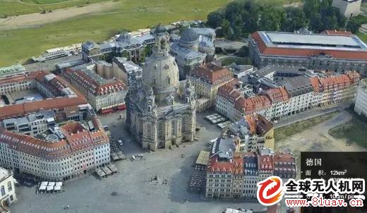
After orthophoto technology, oblique photogrammetry appeared again. The tilt photogrammetry technology comprehensively perceives complex scenes in a wide range, high precision, and high definition. The data generated by efficient data acquisition equipment and professional data processing processes directly reflect the appearance, position, height and other attributes of the object. Real effects and mapping accuracy are guaranteed. At the same time, the production efficiency of the model can be effectively improved. A small and medium-sized city modeling work can be completed in one or two years by artificial modeling. It takes only three to five months to complete the tilt photography modeling method, which greatly reduces the 3D model data. The economic and time cost of collection. At present, the application of tilt photogrammetry technology has been widely carried out at home and abroad, and tilt photography modeling data has gradually become an important content of urban spatial data framework.

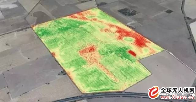
These are all data based on visible light. The data obtained by infrared is even more amazing. This is another brand new industry that Haotian is in contact with - precision agriculture. Remote sensing data is acquired by a near-infrared camera or a multi-spectral camera. Analysis of spectra on images with geographic information can yield many magical data: vegetation coverage, vegetation index, corn vegetation index, late vegetation cover index, and normalized vegetation index. It may be said that these nouns are also confused, the general meaning of these. It is through infrared remote sensing that many plants can be harvested or data on pests and diseases and natural disasters.

Haotian Vision has now introduced the above: the orthophoto image measurement drone industry application customization, tilt photography measurement drone industry application customization, DJI UAV precision agriculture suit.
Because of the sky, so professional!
Our wish is also world peace!
-------------------------------------------------
END
Shanxi Haotian Vision Aviation Technology Co., Ltd.
Dajiang Innovation Shanxi authorized experience store
AOPA civil drone system driver certification training institution
Contact us I Co ntact Us
Company Address: 1601, Unit 3, Block A, Changfeng Pictures, Changfeng Street, Xiaodian District, Taiyuan City
Experience Store Part 1: F561 TEL, Changtian Street, Xiaofeng Street, Xiaodian District, Taiyuan City
Experience Store 2: F587 TEL, Tianmei Xintiandi, Changfeng Street, Xiaodian District, Taiyuan City
Experience store three: Jinan Street, Xiaodian District, Taiyuan City, North America N1 negative floor B083 TEL
As the most authoritative application integrator of the drone industry in Shanxi, Haotian Vision has been learning the application of drones in various industries. We use the new knowledge we have learned about the UAV industry to give back to more UAV industry practitioners and some industries that can bring innovation to UAVs. Recently, we have come into contact with the category of UAV remote sensing mapping, and found that using UAV to obtain data by remote sensing is a magical thing.
Remote sensing technology is a technique for detecting and recognizing a target by sensing electromagnetic waves, visible light, and infrared rays reflected from a target or radiating from a long distance. Traditional remote sensing technologies, such as satellites, airplanes or other aircraft, are costly and have long operating cycles. It has been plagued by the popularity of remote sensing technology to obtain data. Until the emergence of drones, the small size, light weight, flexibility and maneuverability make UAV remote sensing the main force of today's remote sensing technology.
As mentioned above, both visible light and infrared light are detection methods. Let's talk about visible light mapping, using a drone camera with a visible light camera, which is a general digital and SLR camera to obtain surveying and mapping data. This kind of mapping is usually well known as some orthophoto images, and is mostly used in fields such as land surveys, navigation map updates, soil erosion monitoring, and forestry surveys. The data that can be obtained has some spatial information, contour lines, and so on.

After orthophoto technology, oblique photogrammetry appeared again. The tilt photogrammetry technology comprehensively perceives complex scenes in a wide range, high precision, and high definition. The data generated by efficient data acquisition equipment and professional data processing processes directly reflect the appearance, position, height and other attributes of the object. Real effects and mapping accuracy are guaranteed. At the same time, the production efficiency of the model can be effectively improved. A small and medium-sized city modeling work can be completed in one or two years by artificial modeling. It takes only three to five months to complete the tilt photography modeling method, which greatly reduces the 3D model data. The economic and time cost of collection. At present, the application of tilt photogrammetry technology has been widely carried out at home and abroad, and tilt photography modeling data has gradually become an important content of urban spatial data framework.

These are all data based on visible light. The data obtained by infrared is even more amazing. This is another brand new industry that Haotian is in contact with - precision agriculture. Remote sensing data is acquired by a near-infrared camera or a multi-spectral camera. Analysis of spectra on images with geographic information can yield many magical data: vegetation coverage, vegetation index, corn vegetation index, late vegetation cover index, and normalized vegetation index. It may be said that these nouns are also confused, the general meaning of these. It is through infrared remote sensing that many plants can be harvested or data on pests and diseases and natural disasters.

Haotian Vision has now introduced the above: the orthophoto image measurement drone industry application customization, tilt photography measurement drone industry application customization, DJI UAV precision agriculture suit.
Because of the sky, so professional!
Our wish is also world peace!
-------------------------------------------------
END
Shanxi Haotian Vision Aviation Technology Co., Ltd.
Dajiang Innovation Shanxi authorized experience store
AOPA civil drone system driver certification training institution
Contact us I Co ntact Us
Company Address: 1601, Unit 3, Block A, Changfeng Pictures, Changfeng Street, Xiaodian District, Taiyuan City
Experience Store Part 1: F561 TEL, Changtian Street, Xiaofeng Street, Xiaodian District, Taiyuan City
Experience Store 2: F587 TEL, Tianmei Xintiandi, Changfeng Street, Xiaodian District, Taiyuan City
Experience store three: Jinan Street, Xiaodian District, Taiyuan City, North America N1 negative floor B083 TEL
Remote Monitor Systems Battery
Remote Monitor Systems Battery,E Cigarette Lithium Battery,Semi Tight Lithium Battery,Intelligent Oem Lithium Battery
Jiangmen Hongli Energy Co.ltd , https://www.honglienergy.com